Location Beacons

We sometimes get asked for location beacons or which beacons are best for determining location. All beacons can be used for locating. While there are physical aspects such as battery size/life and waterproofing that make some beacons more suitable for some scenarios, locating capability is determined more by the software used rather than the beacons themselves.

Our article on Determining Location Using Bluetooth Beacons gives an overview on locating while the article on Using Beacons, iBeacons for Real-time Locating Systems (RTLS) explains how RTLS work. If you wish to create your own locating software we have a large number of posts on RSSI.

If you have been attracted to Bluetooth by recent announcements on Bluetooth direction finding, be aware that no ready-made hardware or software solutions exist yet. It will take a while, perhaps years, before silicon vendors support Bluetooth 5.1 direction finding, silicon vendors create SDKs and hardware manufacturers create hardware.

Using iBeacons for Locating Robots

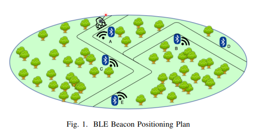
Beacons are great for use with robots for use in determining extra contextual information. There’s recent research on Autonomous Navigation of an Indoor Mecanum-Wheeled Omnidirectional Robot Using Segnet (pdf) that uses iBeacons to determine a rough location of the robot.

The locating uses Kalman filtering and trilateration to get a fix for the robot.

If you want to learn more about using RSSI to determine robot location there’s also a presentation video Robot Localization using Bluetooth Low Energy Beacons RSSI Measures by David Obregón Castellanos.

Read about Using Beacons, iBeacons for Real-time Locating Systems (RTLS)

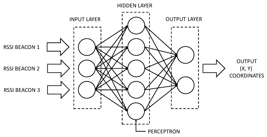
Using AI Machine Learning on Bluetooth RSSI to Obtain Location

In our previous post on iBeacon Microlocation Accuracy we explained how distance can be inferred from the received signal strength indicator (RSSI). We also explained how techniques such as trilateration, calibration and angle of arrival (AoA) can be used to improve location accuracy.

There’s new research presented at The 17th Annual International Conference on Mobile Systems, Applications, and Services (MobiSys ’19) by researchers from Nagoya University, Japan that looks into the use of AI machine learning to process Bluetooth RSSI to obtain location.

Their study was based on a large-scale exhibition where they placed scanning devices:

They implemented a LSTM neural network and experimented with the number of layers:

They obtained best results with the simplest machine learning model with only 1 LSTM:

As is often the case with machine learning, more complex models over-learn on the training data such that they don’t work with new, subsequent data. Simple models are more generic and work not just with the training data but with new scenarios.

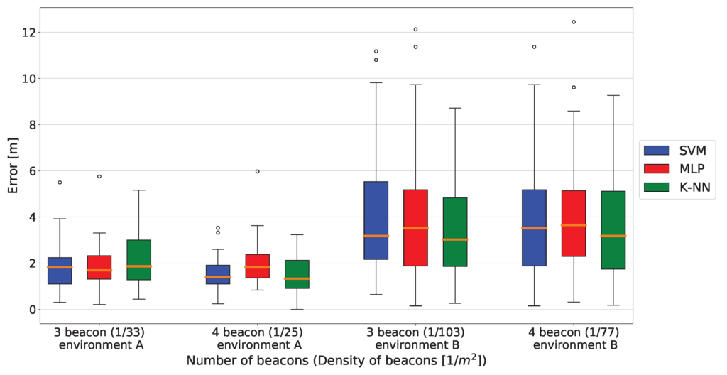
The researchers managed to achieve an accuracy of 2.44m at 75 percentile – whatever that means – we guess in 75% of the cases. 2.44m is ok and compares well to accuracies of about 1.5m within a shorter range confined space and 5m at the longer distances achieved using conventional methods. As with all machine learning, further parameter tuning usually improves the accuracy further but can take along time and effort. It’s our experience that using other types of RNN in conjunction with LSTM can also improve accuracy.

If you want to view the research paper you need to download all the papers from the conference (zip) and extract p558-uranoA.pdf. Some of the other papers also make interesting, if not directly relevant, reading.

Read about AI Machine Learning with Beacons

Information Display and Alerting System Based on iBeacon

There’s new research on a An Intelligent Low-Power Displaying System with Integrated Emergency Alerting Capability. The authors have implemented a wireless ePaper system showing static and dynamic information together with indoor locating based on Bluetooth beacons .


Unfortunately, the locating system is based on an empty room and the technique would be liable to fluctuations in the physical environment.

Read about Using Beacons, iBeacons for Real-time Locating Systems (RTLS)

Owntracks Location Tracking and Alerting

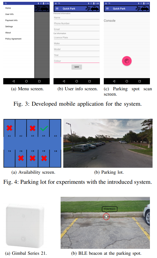
Owntracks is an open source app for iOS and Android that allows you to keep track of your (or vulnerable family member’s) location. However, it also has business uses to track valuable assets. You can also build a private location diary and share it with others.

It works with iBeacons to provide:

  • Locating indoors where GPS doesn’t work
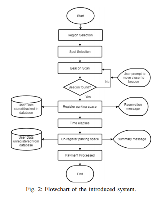
  • Attributing location to a vehicle to track time spent commuting or to see where you have parked your car
  • Fitting to keys/luggage/expensive equipment to get notified when you leave them behind

Trust Range Method of Improving Location Accuracy

A mentioned in our post on location accuracy, two methods of improving accuracy are calibration and trilateration. There’s a recent research paper on iBeacon indoor localization using trusted-ranges model, that explores an alternative ‘trusted-ranges’ method. The method is still based on the RSSI measurements between the beacon and detector. It builds up a trusted-range model to describe how the RSSI varies over time and distance.

The model supplies reliable ranges of received signal strength values from nearest neighbours classifying received signal strength values into various levels of range. It performs better than calibration, especially at shorter ranges, while having a low complexity and hence computationally fast speed.

Enhanced Vehicle GPS Using Beacons

A problem with navigation in vehicles is that location can be lost in radio-shadows such as in tunnels and in tree covered areas. ChoonSung Nam and Dong-Ryeol Shin of Sungkyunkwan University, Suwon, Korea have a new paper on Vehicle location measurement method for radio-shadow area through iBeacon.

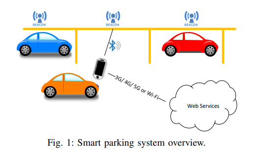
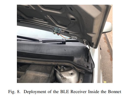
Beacons are placed at the side of the road and instead of advertising unique ids in the form of iBeacon or Eddystone, they advertise absolute Global Positioning System location data. Together with the received signal strength (RSSI) this allows the vehicle to better determine the location.

Hybrid Localisation Method

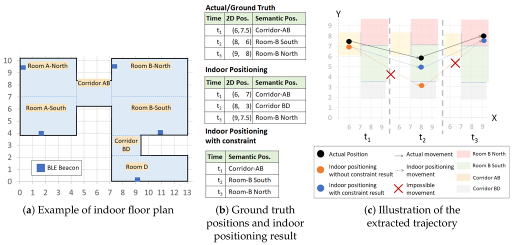
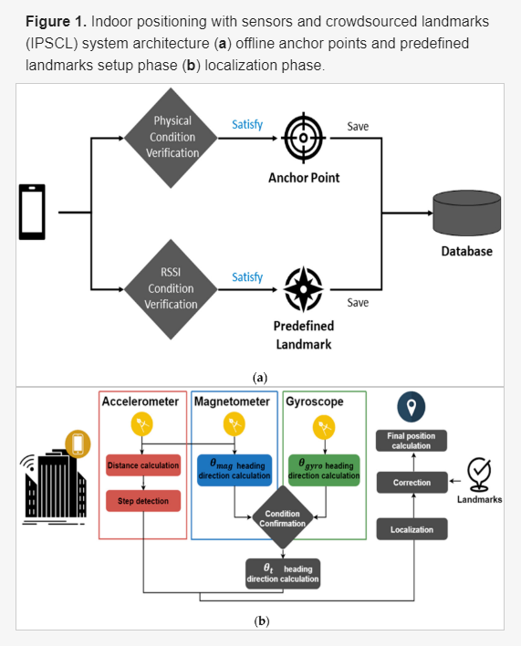
In our previous article iBeacon Microlocation Accuracy, we wrote about ways of using beacon RSSI to determine location. However, what if you were to use and combine beacon RSSI with other ways of locating to create a hybrid method? This is the topic of a new research Unsupervised Indoor Localization Based on Smartphone Sensors, iBeacon and Wi-Fi by Jing Chen Yi Zhang and Wei Xue of Jiangnan University, School of Internet of Thing Engineering, China.

The paper describes UILoc a system combining dead reckoning, iBeacons and Wi-Fi to achieve an average localisation error is about 1.1 m.

The paper also compares the trajectories obtained using different localisation schemes:

Using iBeacons for Motorola TRBONet

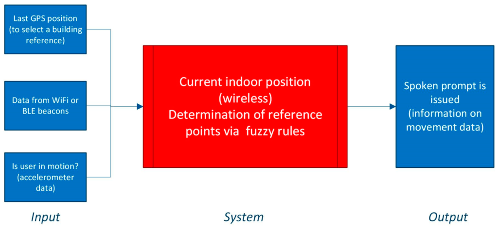
Motorola MOTOTRBO range two-way Radios can be used with the Motorola-supplied TRBOnet PLUS (pdf) control room software to show the location of workers with digital radios on maps and plans. The radios contain both GPS and iBeacon detection to allow locating indoors.

There are three places where iBeacons need to be set up in TRBOnet:

In the GPS profile:

Placing beacon on the map:

Are you an established 2-way radio company?
Contact us for advice on which beacons we have supplied for use with TRBONet.

Read the full User Guide
View compatible beacons

iBeacon Microlocation Accuracy

Customers often ask us the accuracy when locating beacons. In order to get the answer, its necessary to understand different ways of locating and the tradeoffs that are needed to get the different levels of accuracy.

There are two types of locating, received signal strength (RSSI) based and angle of arrival direction finding (AoA).

Locating using RSSI

There are two main scenarios. The first is a where the detector, usually a phone or gateway, is at a known location and the beacon moves. The second is where the beacons are fixed and the detector moves. Either way, the detector receives a unique beacon id and the receiving electronic circuitry provides the strength of the received signal.

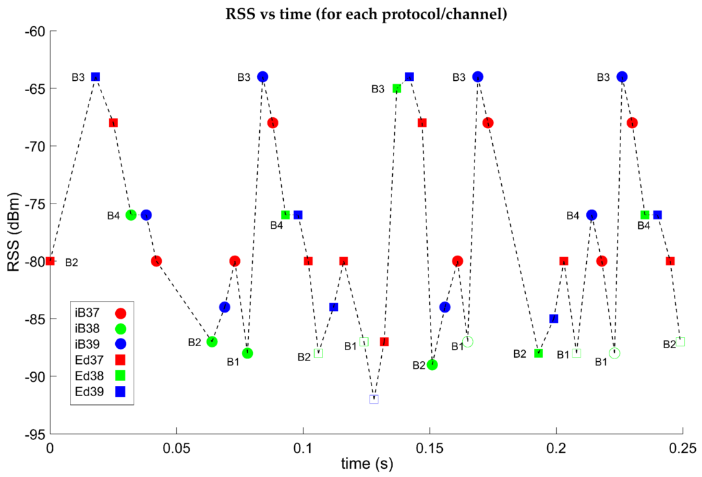
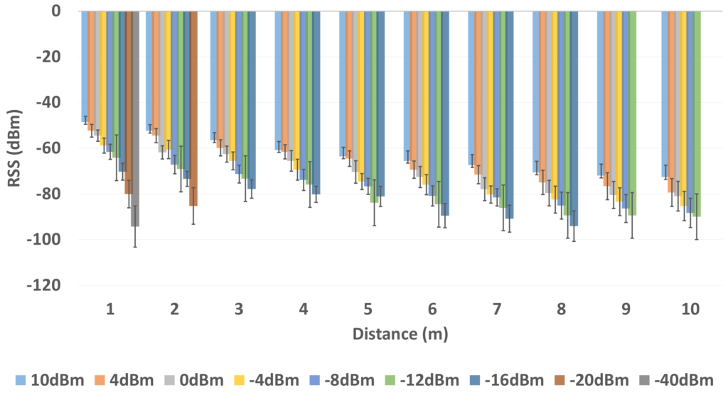
The value of the RSSI can be used to infer the distance from the detector to the beacon. The main problem with RSSI is that it varies too much, over time, to be used to accurately calculate distance. The direction also isn’t known when there’s only one beacon and one detector. The varying RSSI, even when nothing is moving, is caused by the Bluetooth radio signals that are reflected, deflected by physical obstacles and interfered with by other devices using similar radio frequencies. Physical factors such as the room, the beacon not uniformly emitting across a range of 360 degrees, walls, other items or even people can affect the received signal strength. How the user holds a detecting phone can affect the effectiveness of the antenna which in turn affects the signal strength.

The varying RSSI can be smoothed by averaging or signal processing, such as Kalman filtering, to process multiple RSSI values over time. The direction not being known can be solved by using trilateration where three gateways (or beacons depending on the above mentioned scenario) are used to determine the distance from three directions and hence determine the 2D location.

Trilateration

The aforementioned physical factors that affect RSSI can be reduced by measuring the actual RSSI at specific locations and hence calibrating the system.

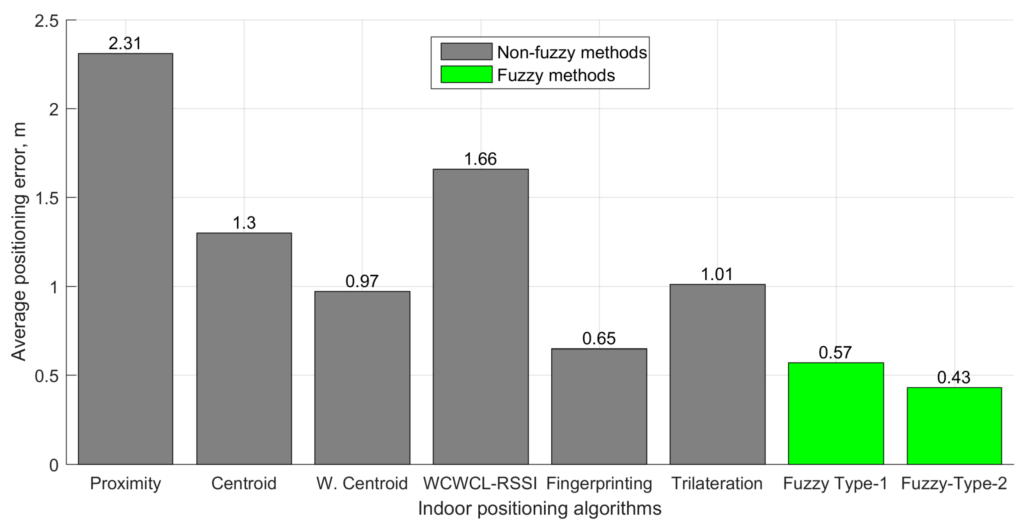
The change of RSSI with distance is greater when the beacon is near the detector. At the outer reaches of the beacon signal, the RSSI varies very little with distance and it’s difficult to know whether the variance is due to a change of distance or radio noise. Hence for systems that use signal processing, trilateration and calibration tend to achieve accuracies of about 1.5m within a shorter range confined space and 5m at the longer distances.

However, such systems have problems. The multiple RSSI values needed for averaging or signal processing mean that you either have to wait a while to get a location fix or have the beacons transmit more often (with a shorter period) that flattens their batteries much sooner. Trilateration requires at least three devices per zone so can be costly and require significant time to setup and maintain. Using calibration is like tuning a performance car. It works well until something small changes and it needs re-tuning. If someone adds a room partition, desk or even something as simple as lots of people in the room, the calibration values become invaid. Re-calibration takes human effort and, pertinently, it’s not always easy to know when it needs re-tuning.

An alternative to trilateration is zoning. This involves putting a detector (or beacon depending on the above mentioned scenario) in each room or zone. The system works out the nearest detector or beacon and can work on just one RSSI value to get a fix quickly. The nearest zone is often all that’s required of most implementations. With zoning, if you need more accuracy in a particular zone you add more detectors in the area to get up to the 1.5m accuracy of other methods. This will obviously be impractical if you need 1.5m accuracy everywhere over a large area.

BeaconRTLS™ area zones

Angle of Arrival Locating

An alternative to trilateration and zoning is more expensive Bluetooth hardware and more complex software that makes use of Angle of Arrival (AoA). Locator hardware with multiple antennas uses Bluetooth Direction Finding to find assets to better than 1m accuracy. Location engine software uses the difference in the time of receiving the signals at multiple antennas to calculate the position. Multiple locators can also be used to cover larger areas and/or improve the accuracy using triangulation.

Unlike RSSI systems where any beacons can be used, locators tend to be tied to using the same manufacturers’ beacons. The complex hardware and software has less throughput and supports fewer beacons. The computing hardware needs to be more powerful. Systems need careful, accurate site measurements to achieve good accuracy.

Summary

Choosing a solution just because it is more accurate, rather than needed, will cost significantly more not just in hardware but in software cost, setup effort and maintenance. Work out what accuracy you need and then seek out an appropriate solution.