Understanding UPS Delivery

We send beacons using UPS for our courier service. When we book a shipment, you will receive a notification email from UPS. However, it’s important to note that this email does not confirm the package has been collected.

The actual pickup of your shipment depends on whether UPS has already completed our collection for the day. If they have, the pickup will take place on the next working day (Monday to Friday). Unfortunately, the pickup time is not fixed and can vary, so we are unable to provide a specific cut of time for next day delivery. To increase the likelihood of same-day dispatch, it’s best to place your order as early in the day as possible.

Additionally, if the initial email from UPS includes a delivery date, we recommend ignoring it. This date is frequently inaccurate and should not be relied upon as a guarantee of when your package will arrive.

For most shipments within the UK, excluding those destined for very remote areas, UPS typically delivers the day after pickup.

BeaconZone Ideas Gallery

BeaconZone was set up in 2015 with the aim of encouraging companies and organisations to explore beyond the confines of retail marketing solutions into areas such as the Physical Web, asset control, security, sensing and the Internet of Things (IoT).

View the Ideas Gallery where you can gain inspiration based on actual BeaconZone customer scenarios.

Tackling Bluetooth AoA Complexity for Real-World Applications

We’ve had several customers express interest in developing their own Angle of Arrival (AoA) software, often starting with basic AoA scripts provided by evaluation boards. Unfortunately, these evaluation scripts are usually insufficient for production-level implementations due to a number of critical limitations.

Evaluation board scripts typically apply basic signal processing techniques that struggle with real-world challenges, especially in areas like noise reduction and calibration. Multipath, that’s signals reflecting and arriving in multiple directions, mitigation is often inadequate, making these scripts less effective in complex environments. Simple scripts usually employ straightforward phase interferometry methods that are limited in their ability to handle multipath scenarios. Additionally, they tend to use outdated AoA IQ-to-Angle algorithms, which further affects performance.

Production systems must be capable of managing multiple tags and anchors simultaneously, in real time. Evaluation scripts, however, are generally designed for a single tag and anchor, lacking the logic necessary for multi-device scenarios. They also don’t include advanced features like parallel processing, trilateration or data fusion across multiple anchors, which are essential for achieving 3D positioning.

Evaluation scripts are also designed for controlled conditions, with minimal error checking. They typically lack robust error detection and correction mechanisms essential for reliability in dynamic environments. Furthermore, these scripts do not incorporate fallback mechanisms, such as temporarily lowering accuracy in the presence of short-term radio frequency noise.

A production-ready system also requires integration with broader ecosystems, such as APIs or interfaces for asset management systems or databases, enabling seamless data flow and operational integration.

Key Areas to Address for Production-Ready AoA Systems:

  1. Advanced Signal Processing: Noise reduction is essential for ensuring accuracy in challenging environments.
  2. Multipath Resolution Algorithms: Needed to distinguish direct signals from reflections, enhancing positional accuracy.
  3. Multi-Device Management: Simultaneously support multiple tags and anchors to enable scalability in deployment.
  4. Data Fusion and Trilateration: Combine data from multiple anchors to calculate precise 3D positioning.
  5. Robust Error Handling: Implement comprehensive error detection, logging, correction and fallback mechanisms for consistent reliability.
  6. Performance Optimisation: Achieve real-time processing by optimising code and utilising hardware acceleration.
  7. System Integration: Enable compatibility with enterprise systems by providing appropriate interfaces and data formats.

By addressing these areas, a production-ready AoA system can achieve the reliability, accuracy, and scalability required for effective deployment in complex, real-world environments.

Read about PrecisonRTLS

Beacon Rollout: Best Practices for Minimising Erroneous Data Collection

Beacon rollout, especially on a large scale, offers both technical and logistical challenges that can be difficult to foresee. One of the primary obstacles lies in ensuring that the test data collected is accurate, reliable, and not impacted by the beacons in transit that haven’t yet been installed. Allied to this, security concerns with certain beacons arise due to the ease of manually switching some models on and off, which can lead to potential tampering after deployment.

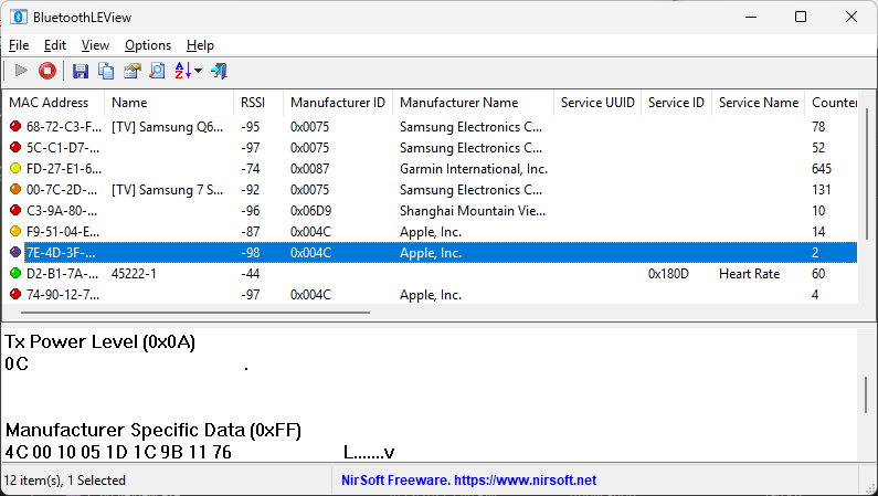
When dealing with numerous beacons in a rollout, one of the foremost issues encountered is the collection of erroneous data from beacons that haven’t been installed yet. As these uninstalled beacons are often carried around during deployment, they can inadvertently be picked up by the network, which results in inaccurate data being associated with incorrect locations. This misleading data can create confusion and additional workload, as it requires careful analysis to separate genuine location data from the erroneous data generated by beacons that are simply in transit.

Some beacon models come with manual switches that are intended to make them easier to manage. While this can be convenient for setup, these accessible switches can also pose a security risk. If someone with malicious intent gains access to the beacons, they may tamper with them, switching them off to disrupt communication or even switching them on in the wrong location. This can undermine the reliability of the data collected and even create security vulnerabilities in the beacon network.

One effective solution we discovered through trial and error is the use beacons without manual switches and large Faraday bags to manage uninstalled beacons. Faraday bags block electromagnetic signals and prevent the beacons from inadvertently transmitting data before they’re installed. By placing beacons inside these bags, we avoid unnecessary data collection and maintain greater control over when and where each beacon starts transmitting.

Privacy vs. Performance: The Challenges Facing Google’s Find My Device Network

Recently, we mentioned Google’s new Find My Device network and how well-known brands like Chipolo and Pebblebee have introduced compatible tracking beacons, with more brands expected to join soon.

However, Google’s Find My Device network has been facing notable criticism for prioritising privacy to the extent that it undermines the platform’s core purpose of effectively locating missing devices. Unlike Apple’s Find My network, which operates on an opt-out model and builds a robust tracking network from the vast majority of users, Google’s Find My Device requires users to actively opt in to share location data. This opt-in system, while reinforcing privacy, has limited network participation and compromised the network’s coverage, especially in areas with fewer users.

Some industry observers argue that Google’s commitment to privacy is unconvincing, given the company’s longstanding practices of data collection across various platforms. The irony of Google promoting user privacy while having a track record of data usage hasn’t escaped the attention of critics, who find the company’s claim to privacy-first design less persuasive in practice. Moreover, users are often left unclear on how to enable full functionality on their devices.

Enhancing Indoor Navigation for Elderly with Cognitive Impairments Using iBeacon and Augmented Reality

A new research paper explores the development and application of an indoor navigation system using augmented reality (AR) technology, aimed at helping older people, especially those with Mild Cognitive Impairment (MCI) and Alzheimer’s disease. The use of technology aims to reduce the burden on caregivers and improve patient safety.

One of the key technologies used in the navigation system is iBeacon. This supports the identification of a user’s position, providing real-time navigation guidance by transmitting a unique signal to devices such as smartphones. iBeacons are strategically placed in buildings, allowing a smartphone or tablet to detect their signals and calculate the proximity to the beacon, aiding in determining the user’s location.

The indoor navigation system utilises iBeacon technology by placing beacons in different locations throughout the environment. As users move, their mobile device interacts with these beacons, receiving signals that help update their position on a digital map and provide step-by-step directions. This system also integrates augmented reality to superimpose visual cues, such as directional arrows, on the device screen, guiding users to their destination.

The use of iBeacon allows the indoor navigation system to function with high accuracy (typically within a few meters), making it suitable for complex environments like nursing homes or hospitals, where patients may have difficulty finding their way without assistance. It also works without requiring constant internet connectivity, which can be a major advantage for offline operation in secure environments. This technology is low cost, easy to deploy, and scalable, making it an ideal solution for healthcare settings focused on enhancing the mobility and autonomy of elderly individuals with cognitive impairments.

Omnissa Workspace Uses iBeacons

Omnissa Workspace is a digital workspace platform that streamlines the management of enterprise devices, applications and user experiences. It combines unified endpoint management, identity and access management, application management, and tools for enhancing employee experiences.

The platform integrates with iBeacon and geofencing technologies to enhance its functionality. Geofencing utilises GPS and Wi-Fi to define larger geographic boundaries, allowing for targeted policies based on user location. These features enable organisations to trigger location-based actions, enhance security, and provide contextual notifications to users. Overall, integration of these technologies offers a flexible approach to managing digital workspaces, improving both security and user experience.

Real-World Performance Evaluation of a Hybrid Bluetooth Low-Energy Positioning and Direction-Finding System

There’s new research evaluating the performance of a Bluetooth Low-Energy (BLE) positioning and direction-finding system under conditions that closely mimic real-world usage. The aim of the study was to enhance a BLE-based hybrid algorithm, which integrates both positioning and direction-finding capabilities. The researchers focused on evaluating the system in realistic conditions, which included using multiple types of devices, separating the devices used for creating the database from those used for evaluation, and ensuring a sufficient time gap between data collection and evaluation measurements.

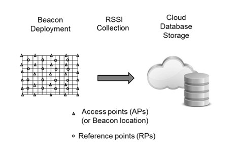
The hybrid algorithm used in the study combines proximity detection, based on the strongest Received Signal Strength Indicator (RSSI), with a fingerprinting approach, where the evaluation data is compared to a pre-existing database. By limiting the search area for positioning to locations with the highest RSSI, the algorithm aims to reduce significant positioning errors. The study also integrated direction-finding functionality into the algorithm, taking into account issues such as signal obstruction caused by the user’s body, which can block radio signals from certain directions.

The evaluation was conducted in a corridor environment, with BLE beacons installed along the walls and ceilings. The research utilised five different smartphone models for both data collection and evaluation. To simulate real usage, measurements were taken from four directions at each evaluation point. The study compared the performance of this hybrid method with a previously proposed method that only included direction estimation based on signal divergence.

The findings demonstrated that the hybrid algorithm significantly outperformed the earlier method in terms of both positioning and direction-finding accuracy, especially under realistic usage conditions. Although the performance of the system declined when the intervals between the BLE beacons were increased, it remained at an acceptable level even with fewer beacons installed. This suggests that the hybrid algorithm is robust and effective, even when the system’s infrastructure is reduced.

In conclusion, the study demonstrated the effectiveness of the hybrid BLE algorithm for positioning and direction-finding in realistic environments. The findings emphasised the importance of conducting performance evaluations under real-world conditions, which better reflect the challenges and variability of actual usage.

iBeacon App Development Considerations

If you are considering writing apps to communicate with iBeacons, here are some high level things you need to think about that are specific to beacon app development:

  • Detecting whether Location and Bluetooth are on/off and alerting the user for permission to use these
  • Detecting beacons in background when the iOS app is closed or the Android app is in doze mode
  • On Android, taking account of the various Bluetooth APIs that exist for the different Android releases
  • Fetching data, associated with a beacon, from a service, such that it’s cached and not fetched every time
  • Arranging for some initial data bundled with the app so that it works straight away without a data connection
  • Fetching data before it is needed such that it’s available with no delay and when there’s no network connection
  • Re-fetching of data when it becomes stale
  • Fetching metadata from the server to control the behaviour of triggering
  • Arranging how Apple will test the app for app review otherwise complications will arise and the review will take weeks
  • Assessing whether to use the mobile OS or manufacturer supplied SDKs (or both)
  • If connecting to beacons, taking account of the unreliability of wireless connections
  • Collecting and uploading statistics/analytics to assess usage
  • Providing end user diagnostics to aid support troubleshooting

Need an experienced beacon app developer to get these things done quicker? Consider our development services.

Creating User Indoor Movement Logs

New research (pdf) looks into the development of an application that tracks user indoor movement logs using Bluetooth beacons. The main focus is on creating a system that is easy to install and use without requiring expertise in beacon installation or positioning analysis. This application is designed for personal home use and simplifies the process by allowing users to install beacons in desired locations, name the spaces and track their movements within the home. The application records users’ movements and the time spent in specific spaces, offering statistical insights such as daily and weekly movement patterns.

The Bluetooth beacons used in this system rely on RSSI (Received Signal Strength Indicator) to estimate the distance between the user’s device and the beacons, with methods like the Kalman filter applied to reduce noise and improve accuracy. To verify its effectiveness, the study conducted experiments comparing manually recorded movement logs with those captured by the application. The results showed an accuracy rate of over 99%, making the system a practical solution for indoor movement tracking in homes, small offices, and other limited spaces.

Key advantages include ease of installation, automatic logging of movement data, and statistical analysis of time spent in different rooms. The application is also suitable for environments like small offices with fewer than 10 employees.